TOPEX-Poseidon
Radar Altimetry:
Averaging the Averages
by
John L. Daly
(5 Dec 2001)
![]()
| Introduction
How many stages of statistical averaging can take place from a body of raw data before the statistical output becomes hopelessly decoupled from the raw data which creates it? Imagine for example getting ten people to take turns at measuring the distance from London to New York using a simple ruler on a large map from an atlas. Each person would give a slightly different reading, perhaps accurate to +/- 10 miles, but if all these readings were averaged, would that make the final resolution of the distance accurate to one mile? Perhaps. But if a thousand people were to do it, would that narrow the resolution to mere yards or metres? Intuitively, we know that would not happen, that an average of the measurements of a thousand people would be little better than an average from ten people. Clearly, there are limits as to how far statistical averaging can be used in this way to obtain greater resolution. An average of even a million such measurements would be scarcely more accurate than the average of ten, diminishing returns from an increasing number of measurements placing a clear limit on the resolution achievable. The problem lay not in the statistics but in the inherent limitations of the measuring devices themselves (in this case, a simple ruler and map). This is precisely the problem which applies in the case of the TOPEX-Poseidon (T/P for short) satellite altimetry system, a joint U.S.-French project which has been active for 9 years measuring `sea surface height' to a claimed resolution, after statistical processing, of around +/- 4.7 centimetres. In other words, that other manifestation of global warming - sea levels - is now being measured from space minus the problems suffered by some tide gauges in tectonic locations. We have become accustomed to having the temperature of the atmosphere being measured from space, using passive `microwave sounding units' (MSU), a temperature record which shows little or no warming and which is at odds with the statistical averages compiled from surface thermometers. Because of this conflict, the greenhouse industry rejects the MSU record in favour of the surface-based averages. But with sea levels, we strangely find that attitudes are reversed, because while tide gauges in the Pacific show no general sea level rise, the T/P system claims to show a rise in sea level averaging 2.2 mm/yr (and squarely within the range of IPCC predictions), even though the overall record is a short one, 9 years. This rise lies well inside the stated margin of error of the system itself. If one accepts the satellite record for temperature, should not this acceptance of space-based monitoring also extend to T/P? Alternatively, if one rejects the temperature record from space (as the IPCC clearly does), why should they be so accepting of T/P? To answer this, we need to determine if the two satellite systems are significantly different, perhaps justifying confidence in one, but caution with the other.
MSU and T/P Compared The fundamental difference between MSU and T/P is that while the MSU is a `passive' system, T/P is an `active' one. MSU merely measures the frequency and intensity of microwave energy radiated naturally from the earth's atmosphere. Being passive, the technological problems are manageable, even with 1970s technology (the MSU has been in service since January 1979). T/P by contrast is an active system, containing an American instrument (TOPEX) and a French one, (Poseidon), in which radar pulses are transmitted down to the surface of the earth in order to measure the echoes from those pulses which bounce off the surface of the ocean and are received back at the satellite. Being an active system, the technological challenges involved are many times greater than for the MSU, and it is this which justifies greater caution when interpreting the results from T/P over such a short time period. (See the Appendix for technical specifications on TOPEX-Poseidon) All radar systems involve the measurement of distance, direction, and even the texture of a distant object by firing a microwave pulse at it and measuring how long it takes for a bounced echo to return from the object. In addition, the radar may also compare the state of the echo with the original pulse that created it to see if any change in shape, pulse length, or wavelength has taken place. This can give clues as to the nature and even the movement characteristics of the object being targeted. Some objects, such as metals and water, make excellent radar `reflectors', while others such as wood, plastics, soft sand etc. are very poor. Also relevant is the angle of the target object to the pulse which strikes it, since a pulse hitting the target at an angle may result in most of the echo being deflected away from the radar. T/P uses two radars, one tuned to 10 GHz (i.e. 10 thousand million cycles per second, each wave being 3 centimetres in length - the `wavelength') and the other to 13.65 GHz (2.3 cm wavelength). The radars transmit pulses of this radiation downward to the sea surface and measures the returning echoes. (Each pulse is actually a frequency modulated `chirp' or a brief shift in the carrier wavelength). Each pulse lasts for about 3 nanoseconds (three thousandths of a millionth of a second), representing a `pulse length' of about 90 centimetres. There are slightly over 1,000 such pulses transmitted every second - called the `pulse repetition frequency'. The speed of light is a fixed and universal constant, at around 300,000 kilometres per second in the vacuum of space. Since these radar pulses, and their echoes, travel at this speed, it merely remains to accurately measure the time interval between the outgoing pulse and the returning echoes to gain a direct estimate of the distance of the target. This measurement then allows sea level to be calculated. The only problem so far is that the claimed accuracy of the sea level measurement is +/- 1.2 metres on the basis of one single pulse and its echo. A simple tide gauge can do a thousand times better than that. But here is where we find statistical averaging come into the picture. T/P does not just settle for one pulse, but sends a thousand of them in a single second, each echo being measured, and each being potentially in error by +/- 1.2 metres. By averaging the results from 1,000 pulses the ranging accuracy can be improved to about +/- 4.7 centimetres. It's a bit like drawing a median line through a wide scatter plot, a common statistical practice. This is a similar principle to the ten people measuring the distance from New York to London with rulers on a map as described in the Introduction. But let's be clear on this point, +/- 4.7 cm is an accuracy derived from statistical processing, not from the individual time measurements of the pulses and their echoes. Consequently, there are limits as to how far statistical averaging can be taken before we end up with illusory numbers, seemingly authoritative, but quite divorced from reality. In the introduction, it was shown that a thousand or a million people measuring the New York-London distance off a map would achieve no better a resolution of the distance than if merely ten people did it. A number would be obtained, expressed to many decimal places - to a matter of yards even, but it would be meaningless if the inherent resolution of the measurement system did not allow such a close estimate. Exactly the same limitation applies to T/P.
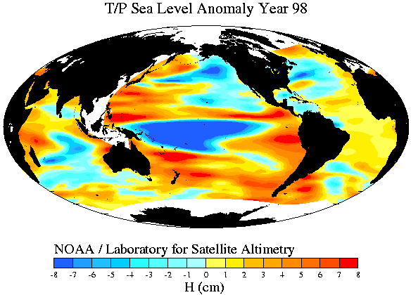
Problems, Problems... There are numerous problems which threaten to compromise the basic accuracy of the T/P system. 1) Height of the Satellite Firstly, if we are to measure the range of a target such as the sea surface, it is essential that we know the height of the satellite itself. If it is higher or lower than we think it is, even by a few metres, the measurement of sea level becomes meaningless. So, the satellite must be continuously tracked so that its height, speed, and angle are precisely known at all times. An airport radar, for example, sits on a fixed point, and so the ranging error of distant aircraft is limited only to the return time of the echo. But suppose the airport radar were itself moving about all over the airport? Chaos would result as the targeting of the aircraft would now be the product of both the aircraft's position and the radar's position. The T/P satellite travels 6 kilometres in a single second, so tracking its position, height, and course is critical in making any sense of the returned echoes. Three independent systems are used to track T/P, one of which is based on laser transmissions from the ground, another being based on positioning from up to six GPS navigation satellites (which are themselves moving at high speed too). The upshot is that the T/P satellite's position is calculated to a claimed accuracy of +/- 3 centimetres. So, even after the thousand pulses are averaged to give an echo ranging accuracy of +/- 4.7 cm, we still have the +/- 3 cm error margin of the satellite position itself to contend with. Combining these two fundamental error factors suggests that the claimed resolution of the system has been heavily overstated. Since T/P began, there have been two TOPEX altimeters on the same satellite, TOPEX-A and TOPEX-B, `A' being used during the earlier period, and supplemented by `B' a few years ago, one following the other, with a period of overlap for calibration. This further complicates the issue since the results from the earlier instrument does not dovetail exactly with the second. Even slight differences in electronic component characteristics (no two similar components are ever identical) can lead to a mismatch between the two. Even differences at the molecular level between components can create significant mismatches when attempting a resolution of mere centimetres over a distance of 1,335 kilometres. 2) Footprint Size A radar pulse is not narrow and pencil-like such as with a laser, rather it leaves the radar as a widening beam, getting wider the further it travels. In its 1,335 km journey down from space, the beam `illuminates' a circle of ocean 3 to 5 km wide, depending on the sea state and the height of the waves. A calm sea affords a narrower footprint (typically 2 km) than if the sea is very rough (typically 10 km). The radar cannot resolve anything closer than that, so all it can do is average out all the thousands of echoes returning from each pulse. The returning echoes are thus a blend of thousands of little echoes from within the footprint, some coming from the troughs of waves, some coming up from wave peaks. With waves up to many metres in height, this creates a mish-mash of echoes from varying heights. Anything within the footprint which is of a different height to the sea will render the echoes harder to decipher which is why T/P does not process echoes when there is any land or islands intruding into the footprint. This also raises the problem of what might happen if there are ships within the footprint - excellent reflectors with large flat horizontal decks beaming echoes directly back to the radar. In other words, a ship echo makes a more powerful echo than the nearby disturbed sea and has the potential to skew the overall echo pattern of the footprint out of all proportion to the size of the ship itself. In busy shipping regions such as the North Atlantic, there may be numerous ships within the footprint, each one sending back an echo from a higher level than the sea surface, while the T/P system itself will be quite ignorant of the presence of those ships. In normal ship-borne radar the greater reflectivity of steel compared with water means that sea waves might only be detectable at 1 to 2 miles from the radar (commonly called `sea clutter' by ship officers), while the much stronger echoes from ships can be detected tens of miles away. The same phenomenon - a disproportionately stronger echo from steel ships as compared with echoes from the sea surface, must inevitably introduce unknown and uncorrectable errors into the T/P system. One of the claims of the T/P system is that its accuracy is calibrated using data from tide gauges mounted on a selected number of oil rigs. Being far out to sea, they are free of the land effects which would prevent sea level readings when land intrudes into the footprint. Yet the rig itself is a perfect reflector, just like ships, making calibration somewhat questionable by this method. Where there is one rig, there is usually several, even within the same footprint, thus compounding the effect. 3) Sea State Trying to measure sea level on a Hawaiian surfing beach would be difficult enough. Doing it from a satellite 1,335 km in space travelling at 6 km per second is `challenging' to put it mildly. Out in the open ocean, a smooth flat sea is very rare. The norm is for waves, some of them several metres in height. Even when there is no wind and the sea surface might be smooth as glass, there is still likely to be a `swell' causing the glassy sea to gently heave up and down as long loping waves progress across the ocean surface, remnants of a storm system perhaps thousands of miles away. The problem of sea state is that both the wave crests and the wave troughs are both returning echoes to the satellite. With wave heights of several metres being typical, the T/P system has to somehow resolve this mish-mash of thousands of echoes from within the footprint, some from wave tops, some from wave troughs, into some sensible average. The statistical correction is further complicated by the fact that wave troughs give better focusing to the beam than do the wave tops which tend to scatter the signal. This would give an impression of lower sea level if there is a strong swell in the sea. That problem is addressed via a statistical model. Because there are so many permutations of sea state (e.g. high steep waves close together, or a low shallow swell, heavy breaking waves, confused wave trains etc.), no one model can represent them all as far as a correction scheme is concerned, and so it is acknowledged that sea state correction is highly uncertain and little understood. In spite of this gap in understanding, the claimed processed resolution of +/- 4.7 cm is still promoted. 4) Atmosphere Errors The speed of light is a universal constant - except when it passes through a denser medium such as the atmosphere. There are two errors that T/P has to cope with, the ionosphere (a highly ionised layer near the top of the atmosphere) and the moist troposphere (from the surface to about 15 km in altitude). Both atmospheric layers slow down the pulse and echo every slightly, and have to be corrected for. T/P uses a second radar on a different wavelength to determine the strength of ionisation in the ionosphere, and uses a passive microwave sounding unit (MSU) to determine the amount of water vapour in the troposphere (which can cause variation in the velocity of the pulse and echoes). These two subsidiary instruments are used to provide a correction factor to adjust the echo data for these two atmospheric effects. 5) Wavelength of the Pulses The T/P pulses are themselves made up `microwaves' which have a peak-to-peak wavelength of 2.3 cm and 3 cm for the two radars used. This imposes an absolute lower limit on range resolution since such a wave cannot discriminate distances shorter than its own wavelength. In other words, +/- 3 cm is the very best resolution theoretically possible even when making the impossible assumption that all other variables are perfectly known and accounted for. 6) Ocean Area Coverage T/P cannot measure sea level when there is any land within the footprint because T/P cannot tell the land echoes from the sea echoes and gives a false result. This means that all sea areas within 3 to 5 kilometres of continental coasts, islands, even atolls, are not covered. Also not covered is all oceanic area north of 66°N or south of 66°S, due to the angled track of the satellite. This results in the Arctic Ocean and the high-latitude part of the North Atlantic being excluded. Also excluded is much of the oceanic area surrounding Antarctica. In areas with a large density of islands such as the Indonesian archipelago or the West Indies, the `no-go' area several kilometres around each island will result in a substantial area of ocean being excluded from sea level measurement altogether. This is shown by the broad white area around Indonesia and the South China Sea in the map of sea surface height in 1999 as shown in Fig.1 below.
7) Other Errors The topography of the earth and the sea bed is not smooth and flat, and so subtle gravity effects can perturb the satellite's trajectory, which means the radar platform's known position may be compromised. A large undersea mountain ridge can affect the sea level above it and these too have to be modelled and applied as a geoidal correction. The tides, which result from gravity interactions between earth, moon, and sun, have to be corrected for, which are very complex on a global scale having an astronomical repeat cycle of 18.5 years. This alone suggests that the global sea level data cannot be used for determining sea level change until a full 18.5 years of tide variability has elapsed, not the 9 years we have so far.
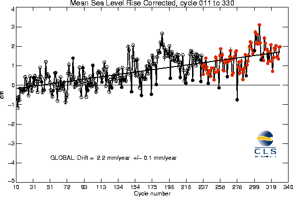
The Bigger Picture As stated earlier, T/P collects raw radar data on sea surface height to a claimed basic observation accuracy of +/- 1.2 metres. But the compounded effect of so many error factors must seriously compromise the claimed processed resolution of +/- 4.7 cm. In effect, this claimed resolution is achieved on the basis of taking an average of an average of an average of an average of an average of echo and positioning data. With so many errors and uncertainties needing correction and adjustment, the final T/P sea level output is many stages of statistical processing removed from the initial raw echo data. Some comparison is made between T/P readings and readings from tide gauges, but since most such gauges are on coasts, the height of the coast behind the tide gauge will muddy the echoes from the footprint in which the tide gauge sits. Using oil rigs is little better as they too return echoes from a different height to that of the sea. And where we find tide gauges, we also find boats and ships - lots of them - to further confuse the echoes. While land can be incorporated into a computer model of no-go areas, ships are impossible to correct for as they are moving about all over the oceans, seemingly at random. Because of the impossibility of correcting for ships, their effect is largely ignored and their significance as an error generator played down or even denied. Even if we wish to accept at face value the claim that T/P really is accurate to +/- 4.7 cm, it is taking statistical averaging to a higher level of absurdity to imagine that we could apply yet more averaging to arrive at sea level changes in millimetres per year. That would be demanding a resolution level that the T/P technology simply does not have. Yet this is precisely what the T/P institutions have done. Recent T/P sea level change charts like this one (Fig.2 below) show not only a rising sea level, but they even quote it to an accuracy of +/- a tenth of a millimetre per year, a quite absurd proposition given the limitations of the technology outlined above.
The sharp calculated rise in sea level at around cycle 175 was attributed by them to the warming effect of El Niño during 1998, and yet only 3 years on, with mostly cooling La Niña conditions worldwide, the T/P is continuing to calculate a sea level rise over and above that achieved by the 1998 El Niño. It is notable especially that the red dots representing the second altimeter, TOPEX-B, are frequently out of step with the earlier one, especially around cycle 278, suggesting calibration problems between the two instruments. Another sharp rise is shown around cycle 299, yet there was no global warming to account for it. The total sea level rise as represented by the trend line in the above graph is around 2 centimetres covering a period of 9 years, not even enough time for the 18.5-year tidal cycle to work itself through. When we consider that the basic measurement of sea level by means of radar only has a claimed accuracy of +/- 1.2 metres, or 1,200 millimetres, to now claim that the accuracy of the sea level trend is accurate to within a tenth of a millimetre, (i.e. 24,000 times greater than the basic resolution) can only be the result of relentless statistical processing and averaging, giving an illusory result rather than a real one, similar to the kind of result one would get if an average were taken of tens of thousands of people measuring the distance between New York and London on a map. Merely expressing a final averaged number to many decimal places does not mean the number itself is accurate to that many decimal places. It is still limited by the measurement system itself, which in the case of a large map would be perhaps 10 miles, not 10 inches. Yet the T/P program is presenting similar such `decimal place' numbers which will always result from extensive averaging, as if they represented real improvements in resolution thousands of times greater than the natural resolution of the technology itself. The institutions controlling T/P have gone far beyond what is possible or appropriate with statistics. It is worth noting that many scientists prefer the T/P system to be used for what it does best - to give a broad global picture of approximate sea level heights and sea states (the `texture' of the echoes can tell us about sea state), and how they vary with ocean currents and events like El Niño. It is not suited to fine detection of global sea level change where accuracies of millimetres or better are needed. Only a network of tide gauges on tectonically stable coasts can do that. This doesn't stop the greenhouse industry trying to talk up T/P, the very people who so readily talk down the data from the much simpler passive temperature-sensing satellites. It is ironic that one of the instruments on T/P for correcting atmospheric error is itself a passive microwave sounding unit (MSU), the very same technology used for the satellite temperature record. In rejecting the validity of the MSU as a temperature record, they should also reject the use of an MSU to correct T/P. Instead, they have applied double standards, rejecting its use in one context, but readily accepting it another.
Conclusion As an example of the best technology available in space monitoring, TOPEX-Poseidon has proved to be a boon to ocean research, not so much because of its sea level averaging, but because of numerous other uses to which this technology has been applied, from detection of El Niño to the tracking of ocean currents and space monitoring of wind speeds through sea state analysis. But while T/P has proved successful in these other areas, its use as a global sea level monitor is highly restrained by the limitations on its accuracy once millimetric scales are sought. To suggest that changes in the global level of the heaving oceans can be determined to a resolution of tenths of a millimetre, or even a centimetre, is to make unsustainable claims about the inherent capabilities of the technology itself. Statistics cannot compensate for the limitations imposed by the electronics and by radiation physics and claims to the contrary are simply not credible. Literature Consulted CNES TOPEX-Poseidon: Ocean and Climate www.cnes.fr/web_uk/activities/programmes/Topex/Top_posd.html Satellite Remote Sensing of the Oceans AVISO Altimetry. How Altimetry Works Altimetry: Life Cycle of a Radar Pulse Ocean Surface Topography from Space - Technology TOPEX/Poseidon Frequently Asked Questions AVISO TOPEX-Poseidon, Mean Sea Level Monitoring Radar Altimetry (PDF) Side-B TOPEX Altimeter Evaluation Long Term Sea Level Change - Univ. of Texas at Austin ( Thanks to Hiram Jacobs for his helpful comments in preparation of this report ) |
| Satellite Altitude Frequency Ku-band radar Ionospheric Delay Ku-band Frequency X-band Radar Ionospheric Delay X-band Radar Pulse Length Pulse Repetition Frequency Orbital Tracking Error Orbital Track Angle Satellite Velocity Footprint diameter - ditto - - ditto - Pulse Type Data Unreliability Threshold Single Pulse Resolution 1,000 Pulse Resolution Sea State Bias Orbital Repeat Time Equatorial Adjacent Track Distance |
1,335 Kilometres 13.65 GHz (2.3 cm wavelength) 0.1 metre 10 GHz (3 cm wavelength) 0.2 metre 3.125 nanoseconds 1,000 pulses per second 2 - 4 centimetres 66° 6 kilometres per second 2 kilometres with a smooth sea 5.5 kilometres with 3 metre wave heights 11.7 kilometres with 15 metre wave heights FM `Chirp' Unreliable with wave heights >6 metres +/- 1.2 metres +/- 4.7 centimetres (not incl. geoid errors) 5% of sea wave heights 9.9 days over any one location 315 kilometres |
![]()
Return to `Cuttings from the Greenhouse' page
Return to `Still Waiting for Greenhouse' main page