Canadian Arctic
 Clyde,
Baffin Island, Canada. Lies on the east coast of Baffin Island within the
Arctic Circle. Data to 1999 . Clyde,
Baffin Island, Canada. Lies on the east coast of Baffin Island within the
Arctic Circle. Data to 1999 .
Eureka,
Baffin Island, in the Canadian Arctic, data to 1995.
Frobisher Bay,
Baffin Island, in the Canadian Arctic, Data to 1999
Inuvik,
Northwest Territory of Canada. Between 1958 and now Inuvik has gone from
a
little Inuit fishing village to a significant
petroleum base, possibly affecting its record. Data to 1995
Mould
Bay, Melville Island, in the Canadian Arctic, data to 1992
 Northeast Canada, Inukjuak,
Coral Harbour & Fort Chimo. Map & model.
Winter temperatures. Data to 2000
Northeast Canada, Inukjuak,
Coral Harbour & Fort Chimo. Map & model.
Winter temperatures. Data to 2000
Resolute,
Devon Island, in the Canadian Arctic, data to 1995.
Sachs
Harbor, Banks Island, in the Canadian Arctic, data to 1985
Alaska
Bethel,
in southwestern Alaska, data to 1999
Cold
Bay, Alaska Peninsula, Alaska, USA. Data
to 1999
Coral
Harbour, Alaska, USA, Data to 1999
Cordova,
Alaska on the south coast. Chart from Alaska Climate Research Center. Data
to 1995
Fairbanks, Alaska. Case study in urbanisation - Raw data for city and university - data differences between them -
Fairbanks adjusted
by NASA-GISS for urbanisation. Data to 2000
Fairbanks & Fort Greely, Alaska, USA.
Fort Greely is 137 km ESE of Fairbanks.
Data to 1999
Gulkana & Fort Greely, Alaska.
Gulkana is in southern Alaska, 150 miles east-northeast of Anchorage. Data to 1999
Point
Barrow, Alaska, showing seasonal temperatures. Data to
2001
Juneau
& Kodiak, Alaska. These stations on opposite sides of the Gulf of
Alaska validate each other. Data to 1999
Kotzebue,
Alaska, adjacent to the Bering Strait. Data
to 1999
Nome,
Alaska, also adjacent to the Bering Strait. Data
to 1999
Northway,
Alaska. Located in the interior. Chart from Alaska Climate Research Center.
Data to 1994
St
Paul Island, Bering Sea, Alaska, USA. This station is far out to sea
from Alaska. Data to 1999
Talkeetna,
Alaska, 200 km north of the capital, Anchorage. Data
to 1999
Yakutat,
Alaska on the south coast. Chart from Alaska Climate Research Center.
Data to 1995
Greenland, Iceland, northern Norway,
and the Arctic Ocean
Akureyri,
north coast of Iceland. This is a remote station facing the Arctic Ocean.
Data to 1999
Angmagssalik
on the east coast of Greenland, is an area tipped to warm +10 degs. Data
to 1999
The `Arctic Rim' - four stations, Ostrov Vize, Danmarkshavn, Svalbard and Franz
Josef Land. Data to 2000
Bear
Island, in the Arctic Ocean directly north of Norway, just inside the
+18 deg. contour. Data to 1999
Bodo,
Norway, is located on the far north coast of Norway, just inside the Arctic
Circle. Data to 1995
Danmarkshavn,
Greenland, seasonal & annual temperature. Plus summer
months temperatures. Data to 2002
Egdesminde,
Greenland. Data to 1999
Franz
Josef Land, Arctic Ocean. This station is only 10° latitude from
the North Pole. Data to 1999
The `GIUK Gap'. Six stations to represent the ocean gap
between Greenland, Iceland, and UK. Data to 2000
Godthaab
on the west coast of Greenland, bears a strong similarity to the trend
at Angmagssalik. Data to 1999
Godthaab
& Angmagssalik, Greenland, summer temperatures, the season for
ice melt. Data to 1999
Ilulissat, Greenland (Jakobshavn
& Egedesminde). Data to 2002
Jan
Mayen Island in the Greenland Sea north of Iceland. Data
to 2000
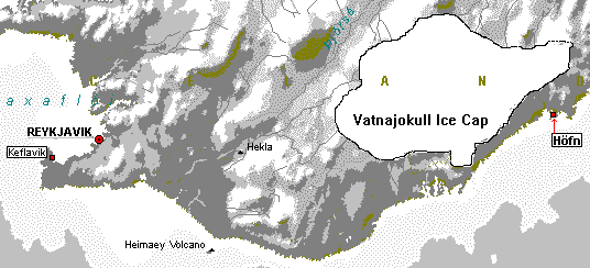
Keflavik
& Hofn, Iceland. Keflavik is a US Air Force base. Hofn is adjacent
to the Vatnajokull Ice Cap. Data to 1999
North Greenland stations. Thule, Dundas &
Danmarkshavn. Data to 2001
Reykjavik,
the capital city of Iceland, is an urban centre. Southern
Iceland Map. Data to 1995
Spitzbergen,
Arctic Ocean. Old data, but it shows the 1960s Arctic cooling very well.
Data to 1975
Stykkisholmur,
a small community on the west coast of Iceland, 100 km north of Reykjavik.
Data to 1998
(thanks to Agust
Bjarnason for the data). Also Stykkisholmur & Teigarhorn, Iceland. Data to 1999
Thorshavn,
Faeroe Islands, North Atlantic Ocean. Halfway between Scotland and Iceland.
Data to 1999
Thule, Dundas Radio & Danmarkshavn,
in Northern Greenland. Data to 2001
Tromo/Skatto,
Norway. Data to 1999
Vardo,
Norway. Lies on the northern Arctic coast of Norway close to the Russian
border.
A valuable continuous long-term record from 1840.
Data to 1999
Russia
Ajan,
eastern Siberia, Russia. This station is on the Russian coast of the Sea
of Okhotsk. Data to 1999
Dzardzan & Olenek,
Siberia, Russia. These stations lie in the Siberian interior near the Lena
River. Data to 1999
Kanin
Nos, Ostrov Vize, & Ostrov Dikson, Russia. On the Arctic coast of Russia. Map.
Data to 1999
Kirensk & Tura, Russia. Rural stations
located north of Lake Baikal in central Siberia. Data to
2000
Korf,
eastern Siberia, Russia. This station is on the eastern coast of the Kamchatka
Peninsula. Data to 1999
Murmansk, Archangelsk (Russia)
& Vardo (Norway for comparison). Map. Data to 2001
Nikolayevsk & Oktiabrskaya, Russia
(Far East). Two stations on opposite sides of the Sea of Okhotsk. Map< | 